SEE THE USA IN YOUR CHEVROLET
Coast to Coast and Border to Border
April 30 to June 9, 2004
Nevada May 3 - 4, 2004
Click any photo to see a double-sized copy of the image. Click BACK in your browser to return to this page.
--Stateline, Nevada, USA
--Carson City, Nevada, USA
Our second state capitol, named in honor of Wild West explorer Kit Carson. Home of the Nevada State Railroad Musuem. We have been through Carson City three years in a row going up Hwy. 395 from Southern California to Reno, Nevada for 'Hot August Nights.' HAN is a 5,000-car show the first week in August including classic cars and street rods from all over the US.


--Fallon, Nevada, USA
--Grimes Point, Nevada, USA
--Sand Mountain, Nevada, USA
--Austin, Nevada, USA
--Hickison Petroglyph Recreation Area, Nevada,
USA
--Eureka, Nevada, USA
--Ely, Nevada, USA
--Connors
Pass, Nevada, USA
--Major's Place, Nevada, USA
--Baker, Nevada, USA.
--Carson City, Nevada, USA
Our second state capitol, named in honor of Wild West explorer Kit Carson. Home of the Nevada State Railroad Musuem. We have been through Carson City three years in a row going up Hwy. 395 from Southern California to Reno, Nevada for 'Hot August Nights.' HAN is a 5,000-car show the first week in August including classic cars and street rods from all over the US.


--Fallon, Nevada, USA
Plenty of green here: alfalfa,
onions, garlic, and cantaloupe fields. There is a U.S. Navy
airbase for carrier-based fighters and bombers here. US 50 runs
on top of the Pony Express route here. Two relay stations'
remains can be seen at Sand Springs and
Cold Springs in this most isolated and dangerous of the Pony Express
Stations.
The Pony Express only ran for 18
months,
beginning in April, 1860. It ran twice a week between St. Joseph,
Missouri
and Sacramento, California, where it linked with San Franciso via
steamship.
It made the 1,966 mile trek in 10 days. Eighty riders, including
then 14 yr. old "Buffalo Bill" Cody, who made the record single run of
322 miles, raced between the 190 stations, switching horses every 10 to
15 miles and averaging 75 miles per run. The completion of the
trans-continental telegraph made the Pony Express obsolete.
--Grimes Point, Nevada, USA
Historic plaques marking Pony Express
and Butterfield Statge stations plus singing sand dune and, ten miles
east of Fallon, a petroglyph site 100-yards north of US 50.
--Sand Mountain, Nevada, USA
Fifteen miles east of Grimes Point, a
half-mile north of US 50 is a sand dune that booms when sand crystals
blow.
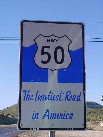
At the turnoff is a sign for the solar-powerd phone saying, "Lonliest
Phone" on the Loneliest Road in America.

|
 That loneliest phone sign. At this point, we were the Loneliest Guys on the Loneliest Road in America. This spot is part way through 106 miles without services. I thought that meant no gas/food/lodging. Heck, there weren't even any residents, cows, roadkill, or other lonely travelers! |

|

|
--Austin, Nevada, USA
110 miles east of Fallon is Austin,
where a Pony Express rider accidentally discovered silver ore in 1862,
starting the silver rush.

|

|
 |

|

|
|
--Eureka, Nevada, USA
We stay here our second night on US 50,
some 360 miles east of Sacramento. (Sign above, right, was the only
photogenic item in Eureka.)
We did speak at length, carrying in our luggage, with Jim and Sharon Rey. Jim is a cowboy artist and we saw some photographs of his work. See his bio at http://claggettrey.com/DB/artist_bio.asp?artist=Jim%20Rey and see his work at: http://claggettrey.com/DB/result.asp?artist=Jim%20Rey&backto=artist_bio.asp?artist=Jim%20Rey and my favorite at: http://claggettrey.com/DB/image_show.asp?ID=3063 Jim has a personal website at http://www.jimrey.com/
We did speak at length, carrying in our luggage, with Jim and Sharon Rey. Jim is a cowboy artist and we saw some photographs of his work. See his bio at http://claggettrey.com/DB/artist_bio.asp?artist=Jim%20Rey and see his work at: http://claggettrey.com/DB/result.asp?artist=Jim%20Rey&backto=artist_bio.asp?artist=Jim%20Rey and my favorite at: http://claggettrey.com/DB/image_show.asp?ID=3063 Jim has a personal website at http://www.jimrey.com/
--Ely, Nevada, USA
Nevada Northern Railway Museum is made
up of the massive Kennecott Liberty Pit copper mines stock. The
White
Pine Public Museum has Pony Express memorabilia on display.

|

|

|

|
 |
 |
 |
 |

|
 |

|
 |
 |

|
| |
|
7,722-foot pass.
--Major's Place, Nevada, USA
--Baker, Nevada, USA.
Baker is the last town on 50 before the Utah border. A bit off 50, we took the detour at 12:15 p.m., but found no food except for a open/unattended gas station with credit card machines and a pop vending machine. Also in the center of 'town' was one open store which said Motel/gifts/antiques. "WHOA" was the word on a large sign at a "T" road intersection between 50 and this town. The lady in the store said there was food available farther down the road at the Great Bend Recreation Area.
We make a run for the border plus 100 miles to the first Utah town, Delta, for lunch. We changed to Mountain Time at the border.
| |
|
| |
|